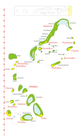
MALDIVES ONLiNE: Mar 11, 2007 <body><script type="text/javascript"> function setAttributeOnload(object, attribute, val) { if(window.addEventListener) { window.addEventListener('load', function(){ object[attribute] = val; }, false); } else { window.attachEvent('onload', function(){ object[attribute] = val; }); } } </script> <div id="navbar-iframe-container"></div> <script type="text/javascript" src="https://apis.google.com/js/platform.js"></script> <script type="text/javascript"> gapi.load("gapi.iframes:gapi.iframes.style.bubble", function() { if (gapi.iframes && gapi.iframes.getContext) { gapi.iframes.getContext().openChild({ url: 'https://www.blogger.com/navbar.g?targetBlogID\x3d2565417034522534591\x26blogName\x3dMALDIVES+ONLiNE\x26publishMode\x3dPUBLISH_MODE_BLOGSPOT\x26navbarType\x3dBLUE\x26layoutType\x3dCLASSIC\x26searchRoot\x3dhttps://maldives-online.blogspot.com/search\x26blogLocale\x3den_US\x26v\x3d2\x26homepageUrl\x3dhttp://maldives-online.blogspot.com/\x26vt\x3d-5097413825056165860', where: document.getElementById("navbar-iframe-container"), id: "navbar-iframe", messageHandlersFilter: gapi.iframes.CROSS_ORIGIN_IFRAMES_FILTER, messageHandlers: { 'blogger-ping': function() {} } }); } }); </script> SCREEN RESOLUTION HAS TO BE 1152*864


<$Sunday, March 11, 2007h5>
<$
Maldivian Air Taxi and Trans Maldivian Airways are the sea plane operators in the Maldives. They offer the most efficient and comfortable sea plane transfers from the airport to the prospective holiday destination.


Labels: , , , , , , ,

<$
Shaviyani Atoll


Shaviyani Atoll is an
atoll located in northern end of the Maldives

Geography
The atoll is situated in between Haa Dhaalu Atoll and Noonu Atoll, in Maldives. 37 miles long, it is the third atoll from the northern edge of the country, and is assigned the letter 'C' as the atoll code. It comprises 51 islands of which 16 are inhabited.


Economy
The population of the atoll crossed 14000 in 2003.

Fishing and agriculture form the mainstay of the atoll's economy. Fishing is engaged in throughout the year, with pole, line and reef fishing practised in various islands in the atoll. The atoll is also known for craftsmanship, such as mat and rope weaving.

Several inhabitants work in the tourism industry and other commercial trades in the Maldivian capital, Malé.

Administration
The atoll office is responsible for public services, development and economic affairs. The Shaviyani Atoll Office was founded in 1958. Operating from Lhaimagu earlier, it was shifted to the current capital Funadhoo in January 1968.


Atoll Summary
Administrative name Shaviyani Atoll
Atoll name Miladhunmadulu
Location 6°30' N and 5°58' N
Letter C
Abbreviation Sh (ށ)
Capital Funadhoo
Population 14502
No. of Islands 51
Inhabited Islands 16
Atoll Chief Mohamed Mahir

Inhabited Islands
Bileffahi Feevah Feydhoo Firunbaidhoo Foakaidhoo Funadhoo Goidhoo Kanditheemu Komandoo Lhaimagu Maakandoodhoo Maaungoodhoo Maroshi Milandhoo Narudhoo Noomaraa

Labels: , , , , ,

<$
Haa Dhaalu Atoll


Haa Dhaalu Atoll is an atoll located in northern Maldives. There is a domestic airport on the island of Hanimaadhoo about 20km from its capital Kulhudhuffushi.


Atoll Summary
Administrative name Haa Dhaalu Atoll
Atoll name Thiladhunmathi
Location 6° 48' N and 6° 30' N
Letter B
Abbreviation HDh (ހދ)
Capital Kulhudhuffushi
Population 21875
No. of Islands 35
Inhabited Islands 16
Atoll Chief Mohamed Didi


Inhabited Islands
Faridhoo Finey Hanimaadhoo Hirimaradhoo Kulhudhuffushi Kumundhoo Kunburudhoo Kurinbi Maavaidhoo Makunudhoo Naivaadhoo Nellaidhoo Neykurendhoo Nolhivaram Nolhivaranfaru Vaikaradhoo


Uninhabited Islands
Bodunaagoashi, Dafaru Fasgandu, Dhorukanduhuraa, Fenboahuraa, Hirinaidhoo, Hondaafushi, Hondaidhoo, Innafushi, Kamana, Kattalafushi, Kaylakunu, Kudamuraidhoo, Kudanaagoashi, Muiri, Rasfushi, Ruffushi, Vaikaramuraidhoo, Veligandu


Resort islands, Airports and Industrial islands are also considered uninhabited

Labels: , , , , , ,

<$

Haa Alif Atoll


Haa Alif Atoll is the northern-most atoll of the Maldives. It contains 42 islands, 16 of which are inhabited.


Atoll Summary

Administrative name Haa Alif Atoll
Atoll name Thiladhunmathi
Location 6° 48' N and 7° 07' N
Letter A
Abbreviation HA (ހއ)
Capital Dhiddhoo
Population 19251
No. of Islands 42
Inhabited Islands 16
Atoll Chief Mohamed Rasheed [1]
Inhabited Islands
Baarah Berinmadhoo Dhiddhoo Filladhoo Hathifushi Hoarafushi Ihavandhoo Kelaa Maarandhoo Mulhadhoo Muraidhoo Thakandhoo Thuraakunu Uligamu Utheemu Vashafaru
Uninhabited Islands
Alidhoo, Alidhuffarufinolhu, Beenaafushi, Dhapparu, Dhapparuhuraa, Dhigufaruhuraa, Dhonakulhi, Gaafushi, Gaamathikulhudhoo, Gallandhoo, Govvaafushi, Huraa, Huvahandhoo, Innafinolhu, Kudafinolhu, Maafahi, Maafinolhu, Madulu, Manafaru, Matheerah, Medhafushi, Mulidhoo, Naridhoo, Umaraiffinolhu, Ungulifinolhu, Vagaaru, Velifinolhu

Resort islands, Airports and Industrial islands are also considered uninhabited

Labels: , , , ,

<$
An atoll is a type of low, coral island found in tropical oceans and consisting of a coral-algal reef usually surrounding an interior body of water called a lagoon. Atolls generally mark the locations of subsided (or sunken) extinct volcanic islands; the shape of the atoll is determined by the initial coastline of the original volcanic island, and is maintained so long as coral growth is faster than subsidence, and is not disturbed by other factors. Some atolls contain volcanic remnant islands at their centers. An atoll's low coral-sand islands form as a result of wave action breaking off pieces of coral at the reef escarpment and piling them up behind.

Usage

The word atoll comes from the Dhivehi (an Indo-Aryan language spoken on the Maldive Islands) word atholhu (Dhivehi: އަތޮޅު). Its first recorded use in English was in 1625. However, the term was popularised by Charles Darwin (1842, p. 2), who described atolls as a subset in a special class of islands, the unique property of which is the presence of an organic reef. More modern definitions of atoll are those of McNeil (1954, p. 396) as "...an annular reef enclosing a lagoon in which there are no promontories other than reefs and [islets] composed of reef detritus" and Fairbridge (1950, p. 341) "...in an exclusively morphological sense, [as] ...a ring-shaped ribbon reef enclosing a lagoon in the center."

Formation

This animation shows the dynamic process of coral atoll formation. Corals (represented in tan and purple) settle and grow around an oceanic island, forming a fringing reef. In favorable conditions, the reef will expand, and the interior island will subside. Eventually the island completely subsides beneath the water, leaving a ring of growing coral with an open lagoon in its center. The process of atoll formation may take as long as 30 million years to occur.Darwin published an explanation for the creation of coral atolls in the South Pacific (1842) based upon observations made during a five-year voyage aboard the HMS Beagle (1831–1836). His explanation, which is accepted as basically correct, involved considering that several tropical island types—from high volcanic island, through barrier reef island, to atoll—represented a sequence of gradual subsidence of what started as an oceanic volcano. He reasoned that a fringing coral reef surrounding a volcanic island in the tropical sea will grow upwards as the island subsides (sinks), eventually becoming a barrier reef island (as typified by an island such as Bora Bora and others in the Society Islands). The fringing reef becomes a barrier reef for the reason that the outer part of the reef maintains itself near sea level through biotic growth, while the inner part of the reef falls behind, becoming a lagoon because conditions are less favorable for the corals and calcareous algae responsible for most reef growth. In time, subsidence carries the old volcano below the ocean surface, but the barrier reef remains. At this point, the island has become an atoll.

Atolls are the product of the growth of tropical marine organisms, so these islands are only found in warm tropical waters. Volcanic islands located beyond the warm water temperature requirements of reef building (hermatypic) organisms become seamounts as they subside and are eroded away at the surface. An island that is located where the ocean water temperatures are just sufficiently warm for upward reef growth to keep pace with the rate of subsidence is said to be at the Darwin Point. Islands more polar evolve towards seamounts or guyots; islands more equatorial evolve towards atolls (see Kure Atoll).

Reginald Aldworth Daly offered a somewhat different explanation for atoll formation: islands worn away by erosion (ocean waves and streams) during the last glacial stand of the sea of some 300 feet below present sea level, developed as coral islands (atolls) (or barrier reefs on a platform surrounding a volcanic island not completely worn away) as sea level gradually rose from melting of the glaciers. Discovery of the great depth of the volcanic remnant beneath many atolls (see Midway Atoll), favors the Darwin explanation, although there can be little doubt that fluctuating sea level has had considerable influence on atoll and other reefs.


Distribution and size

Portion of a Pacific atoll showing two islets on the ribbon or barrier reef separated by a deep pass between the ocean and the lagoon.
An atoll in the western Pacific OceanThe distribution of atolls around the globe is instructive: most of the world's atolls are in the Pacific Ocean (with concentrations in the Tuamotu Islands, Caroline Islands, Marshall Islands, Coral Sea Islands, and the island groups of Kiribati and Tuvalu) and Indian Ocean (the Maldives, the Laccadive Islands, the Chagos Archipelago and the Outer Islands of the Seychelles). The Atlantic Ocean has no large groups of atolls, other than eight atolls east of Nicaragua that belong to the Colombian department of San Andres and Providencia.

As noted above, reef-building corals can thrive only in warm tropical and subtropical waters of oceans and seas, and therefore atolls are only found in the tropics and subtropics. The northernmost atoll of the world is Kure Atoll at 28°24' N, along with other atolls of the Northwestern Hawaiian Islands. The southernmost atolls of the world are Elizabeth Reef at 29°58' S, and nearby Middleton Reef at 29°29' S, in the Tasman Sea, both of which are part of the Coral Sea Islands Territory. The next southerly atoll is Ducie Island in the Pitcairn Islands Group, at 24°40' S. Bermuda is sometimes claimed as the "northernmost atoll" at a latitude of 32°24' N. At this latitude coral reefs would not develop without the warming waters of the Gulf Stream. However, Bermuda is what is termed a pseudo-atoll because its general form, while resembling that of an atoll, has a very different mode of formation. While there is no atoll directly on the Equator, the closest atoll to the Equator is Aranuka of Kiribati, with its southern tip just 12 km North of the Equator.

In terms of total area (lagoon plus reef), the largest atolls are found in the Maldives: Huvadhoo Atoll, having an area of 2800 (or 3200?) km²; the area of Thiladhunmathi and Miladhunmadulu Atolls (two names, but a single atoll structure) is even larger at 3680 km². Another large atoll is Lihou Reef in the Coral Sea, with a lagoon of 2,500 km². However, by far the largest atoll structure of the world is the Great Chagos Bank in the Indian Ocean, a mostly submerged atoll, part of the Chagos Islands, with an area of roughly 13,000 km². If Saya de Malha Bank were to be recognized as a wholly submerged atoll structure, it would be the world's largest, at 40,000 km². Kwajalein in the Marshall Islands, which is sometimes listed as the largest atoll of the world (largest in the Pacific), measures only 846 km², by contrast. Large atolls are also found in the Tuamotu Archipelago, the largest being Rangiroa, with a lagoon area of 1018 km².

In most cases, the land area of an atoll is very small in comparison to the total area. The largest atoll in the world in terms of "land area" (land "permanently" above sea level) is Kiritimati (321.37 km² land area; according to other sources even 575 km²), 160 km² main lagoon, 168 km² other lagoons (according to other sources 319 km² total lagoon size). If the Caicos Islands are to be considered a huge coral atoll, with the Caicos Bank as a lagoon, this complex would be the largest atoll in land area (460.2 km²) and second largest in total area (lagoon size roughly 3,700 km²).

Labels: , , , , , , , , , ,

<$
Maldives consist of 26 atolls which have been divided into 20 administrative districts and one capital city (Malé). The northern most atoll is Haa Alif and the southern most is Seenu. The smallest is Gnayivani Atoll with only one islet . The largest atoll in both the Maldives and the whole world is Gaafu Alif which is just south of the one and a half degree channel.

Each atoll is administered by an Atoll Chief (Atholhu Veriyaa). The president (Maumoon Abdul Gayoom) appoints atoll chiefs to each atoll, who administers it as may be decreed and directed by the president. The Ministry of Atoll Administration and its Northern and Southern Regional Offices, Atoll Offices and Island Offices are collectively responsible to the President for Atolls Administration. The administrative head of the island is the Island Chief (Katheeb), appointed by the Ministry of Atolls Administration. The Island Chief's immediate superior is the Atoll Chief.


Letter Abbr. Local letter Administrative name Former division
A HA ހއ Haa Alif Thiladhunmathi
B HDh ހދ Haa Dhaalu
C Sh ށ Shaviyani Miladhunmadulu
D N ނ Noonu
E R ރ Raa Maalhosmadulu
F B ބ Baa
G Lh ޅ Lhaviyani Faadhippolhu
H K ކ Kaafu Malé Atoll
U AA އއ Alif Alif Ari Atoll
I ADh އދ Alif Dhaal
J V ވ Vaavu Felidhu
K M މ Meemu Mulaku
L F ފ Faafu Nilandhé
M Dh ދ Dhaalu
N Th ތ Thaa Kolhumadulu
O L ލ Laamu Haddhunmathi
P GA ގއ Gaafu Alif Huvadhu
Q GDh ގދ Gaafu Dhaalu
R Gn ޏ Gnaviyani Fuvammulah
S S ސ Seenu Addu

Malé (city)
The names of most of the atolls are simply the names of letters of the Thaana alphabet. Thaana is used to write Dhivehi, the language of the Maldives, and is related to both the Arabic and Devanagari alphabets.

Labels: , , , , , , ,

<$


Constitution of the Maldives

The first Constitution of the Maldives was proclaimed on December 2, 1932, under the rule of Sultan Muhammad Shamsuddeen III. He issued a decree on March 19, 1931, to compile a written Constitution.

In 1930 Bernard H. Bourdill, the then acting Governor of Ceylon, visited Malé to advise the Sultan and the government of the Maldives in drafting of the First Constitution. His visit was made at the request of the Maldivian Government.

The compiled Constitution contained 92 articles. It took exactly 1 year, 8 months and 22 days from the Sultan's decree to draft a Constitution to the ratification of the document.

President of the Maldives

The President of the Maldives is the ceremonial head of state and first citizen of Maldives and the supreme commander of the Maldivian armed forces.

The current President of the Republic of Maldives is Maumoon Abdul Gayoom.


List of presidents
Mohamed Amin Didi, 1953
Ibrahim Nasir, 1968 - 1978
Maumoon Abdul Gayoom, 1978 - Present


Maumoon Abdul Gayoom

Maumoon Abdul Gayoom (Dhivehi: މައުމޫނު އަބްދުލް ގައްޔޫމް) (born December 29, 1937), has been the president of the Republic of Maldives since November 11, 1978, having succeeded Ibrahim Nasir. He was last re-elected to a sixth five-year term in October 2003 with 90.28% of the vote. He was the sole candidate, having been chosen by the Majlis or Assembly. The election is carried out as a referendum and a yes or no vote is chosen by the public.

Early and personal life
Maumoon Abdul Gayoom is the son of Abdul Gayoom Ibrahim (Maafaiygey Dhon Seedhi) and Khadheeja Moosa. His father had 25 children by 8 different wives and Gayoom is the 10th in his family. His mother died when he was studying in Cairo, Egypt. Gayoom's father who died in 1982, at the age of 87, saw the first term of his son's presidency.

Much of Gayoom's early life was spent in Egypt. He was among the 15 students selected at the direction of the then-president Mohamed Amin Didi for special education overseas. At the age of 10, he left to Egypt on September 15, 1947 but was to stay in Ceylon for few days. However his departure from Ceylon to Egypt was delayed for two and a half years, because of the Arab- Israeli conflict started due to recognition of the Israel by the United Nations, at the end of the World War II. When the situation improved, with the end of war in middle-east, he left to Egypt in March 1950 along with other Maldivian students. He spent almost 24 years outside Maldives except for the brief period he once came to Maldives in 1964. After sometime in Maldives, again he left to Egypt to begin studying for Diploma of Education. He did complete his MA degree in 1966 but could not complete his PhD due to funding issues (See sub-section, Education). After completing his MA degree, he worked in American University in Cairo, in 1967, as research assistant in Muslim History under professor Mardsen-Jones. There he worked for almost 2 years and left to Kano, Nigeria.

In 1965 Gayoom met Nasreena Ibrahim, a student who had just arrived to Cairo from the Maldives for her studies. She was 15 then and Gayoom was 27. Four years later they married in Cairo, on July 14, 1969. Just few weeks after his marriage, he joined Ahmadu Bello University in Kano, Nigeria as lecturer in Islamic Studies and moved there with Nasreena. In March 20, 1970, at the age of 20, Nasreena gave birth to twins, Dhunya Maumoon and Yumna Maumoon. When Nasreena got pregnant for the second time it was arranged to send her to Malé. She gave birth to their first son, Farish, in Malé, on March 31, 1971. Nine years later, during Gayoom's presidency, Ghassan Abdul Gayoom was born on June 12, 1980.

During his time at Egypt he was particularly interested in Egyptian Political Affairs. He was closely following the revolutionary movement accelerated by the Muslim Brotherhood and Free Officers Movement of Gamal Abdel Nasser. He attended several public meetings of Muslim Brotherhood where celebrated orators like Sayyid Qutb railed against Britain, imperialism and King Farouk's Government. In July 1952 Gayoom was at Muslim Brotherhood camp, on holiday, when Gamal Abdel Nasser took over the power in a bloodless military coup. In his book A Man for All Islands, biographer Royston Ellis wrote, "Maumoon regarded it as a privilege to be able to hear Sayyed Qutb".


Education

Maumoon Abdul Gayoom acquired his education from Al-Azhar University of Egypt. He went to Egypt in March 1950 when he was 12. In Egypt he spent six months learning Arabic in order for his enrolment in the Faculty of Sharia and Civil Law.

In 1966, he obtained his Bachelor's degree and Master's degree in Islamic Sharia and civil Law, with the degree of excellence with honors. In addition to his MA from Al-Azhar University, he obtained a second Masters Degree in the same field from the American University in Cairo. Gayoom came out first in the Faculty of Islamic Law and Studies, at Al-Azhar University and was awarded his graduation certificate by Gamal Abdel Nasser.

Maldivian government decided to stop the grants for Maldivian students at Al-Azhar University for their attempted interference with then Prime Minister, later president, Ibrahim Nasir's decision to establish diplomatic ties with Israel. Fourteen Maldivian students on Gayoom's direction, including Gayoom himself, sent a signed letter to Ibrahim Nasir to reconsider the decision. Consequently their grants were stopped. The students were then financed by the Egyptian Government. By the time Gayoom acquired his MA degree, Egyptian government decided to stop the funding. As a result of being "black listed", by the government for his attempted intervention, Gayoom decided not to go back to Maldives. Financially he was prevented from completing his PhD. Later with his marriage he decided not to go further with his studying.


Career and politics

Before returning to Maldives, after his studies, Gayoom worked in American University in Cairo in 1967 and Ahmadu Bello university in Kano, Nigeria as lecturer in Islamic Studies for two years from 1969. When his two year contract with Ahmadu Bello university ended, he decided to return to the Maldives. After almost 24 years since he first departed Maldives for studies, he returned to Maldives in 1971?. Three weeks after arrival he joined Aminiyya School as a teacher where he taught English, Arithmetic and Islam. In 1972 he was appointed as the manager of the Government shipping department.

On March 12, 1973, Gayoom was held under housearrest for criticising president Ibrahim Nasir's policies. In May 1973 he was tried in court and by the end of trial he was sentenced to banishment for four years, in May 14, 1973. A week after the sentence, on May 21, he was taken to Makunudhoo island of Haa Dhaalu Atoll. By the time he served 5 months of his punishment, Gayoom was released on October 13, 1973, by Ibrahim Nasir's amnesty following his re-election for another five-year term.

In 1974 Gayoom was appointed as under-secretary in the Telecommunications Department. After ten weeks he was promoted to Director of the department. During this period he worked as a part-time teacher in some private schools, teaching Islam, Arabic and English.

In July 28, 1974, Gayoom was again arrested for criticising Nasir's policies. This time he was kept in solitary confinement in a prison nicknamed "China garden", in Malé. The prison was famous by this name because Chinese fishermen were once detained there. This prison was later demolished in Gayoom's presidency and built Islamic Centre on the block. After 50 days in jail he was set free in September 1974. Six weeks later, he was appointed as Special under-secretary in the then Prime Minister Ahmed Zaki's office. The post of Prime Minister was abolished with the removal and banishment of Ahmed Zaki from office, in March 6, 1975. With this decision, Gayoom's position as the Prime Minister's special under secretary was no longer required. He was officially given notice, when he was in Colombo, and told that he would not be needed in government anymore. However, when he returned from Colombo, he was made the Deputy Ambassador of the Maldives in Sri Lanka. In 1975 he was sent to the United Nations, for two months, as a member of the Maldives delegation. Upon his return, he was appointed as under-secretary at the department of External Affairs. After nine weeks he was appointed as the Deputy Minister of Transport. One year later he was tenured at the United Nations, from September 1976 to January 1977, till Nasir summoned him back from UN at the end of the session.

In March 29, 1977, Gayoom was appointed as Minister of Transport, making him a member of Ibrahim Nasir's cabinet. He was Minister of Transport till November 10, 1978.


Presidency

As Ibrahim Nasir's second term was coming to an end, he wanted someone else running for the presidency. In June 1978 Citizen's Majlis was called upon to declare a nominee for the President. During this voting 45 voted for Nasir and remaining 3 voted for Gayoom. There was another ballot on June 16, in which four people participated. 27 voted for Gayoom, enough for him to be put forward as a candidate. Five months later he was elected with 92.96% of the votes as the new President of the Maldives. The grand reception of his inauguration was held at Majeediyaa School on the night of November 10, 1978. Since then he has been re-elected and still is the President of the Maldives. In 1983 referendum he was re-elected by 96.62%, for the second term. He is currently in his sixth five-year term, making him Asias second-longest serving leader after Lee Kuan Yew of Singapore. The President of the Maldives is both the Head of Government and Head of State, with very little distinction between the two roles, therefore President Gayoom is also the Commander-in-Chief of the Maldivian armed forces, the National Security Service.


Notable visits and participations

The first Country Gayoom visited as the president was Libya. His visit in September 1979 to Libya was to participate in celebration held to mark the 10th anniversary of the September Revolution.
In 1981 Gayoom attended third Islamic Summit Conference of Organization of the Islamic Conference held in Saudi Arabia. Since then he attended every ISC meetings. These have been in Morocco in 1984, in Kuwait in 1987, in Senegal in 1991, in Morocco in 1994 and in Pakistan in 1997.
In May 1981 he made state visits to neighboring Asian countries, Singapore and Malaysia
His first visit to a western country, as the president, was on May 10, 1982 to London.
In October 1982 he participated Commonwealth heads of Government Regional Meetings in Fiji
In March 1984 he made a state visit to Sri Lanka to repair the cracked relations with two countries.
In 1983 he made a state visit to North Korea. The same year, in October, he made a visit to South Korea. During this visit he was awarded the Grand Order of Mugunghwa, the highest order of the Republic of Korea. He invested the president, Chun Doo Hwan, with the Maldivian order of Nishan Izzuddeen.

Criticism

Gayoom has been harshly criticized by many for his autocratic rule, and he is widely considered to be a dictator and has been accused of nepotism. This may be because he has several family members, in-laws and close relatives in high posts in his government and cabinet. According to Amnesty International, in the year 2003 "there were severe restrictions on freedom of the press, and political parties were unable to function." Anti-government riots broke out in the country in September 2003 following a prison shooting incident. Opposition to the president has come in the form of the Maldivian Democratic Party. Political prisoners are often banished to remote atolls. Gayoom was also the defense minister and finance minister of Maldives for a long time, but gave up these positions on September 1, 2004, following international pressure, and media and public ridicule.

Labels: , , , , , , , ,

<$

Area:
total: 300 km²
land: 300 km²
water: 0 km²

Coastline: 644 km

Maritime claims: measured from claimed archipelagic baselines
contiguous zone: 24 nautical miles (44 km)
exclusive economic zone: 200 nautical miles (370 km)
territorial sea: 12 nautical miles (22 km)

Elevation extremes:
lowest point: Indian Ocean 0 m
highest point: unnamed location on Vilingili Island in the Addu Atoll 2.4 m (Maldives is the flattest country in the world, i.e. they have the lowest high-point of any country in the world).


Resources and land use
Natural resources: fish

Land use:
arable land: 10%
permanent crops: 0%
permanent pastures: 3%
forests and woodland: 3%
other: 84% (1993 est.)

Irrigated land: NA


Environmental concerns
Natural hazards: low level of islands makes them very sensitive to sea level rise

Environment - current issues: depletion of freshwater aquifers threatens water supplies; global warming and sea level rise; coral reef bleaching, overpopulation, deforestation, air pollution

Environment - international agreements:
party to: Biodiversity, Climate Change, Climate Change-Kyoto Protocol, Hazardous Wastes, Ozone Layer Protection
signed, but not ratified: Law of the Sea


Other facts
Position: degree of latitude: 07° 06'30" N to 00° 41'48" S and degree of longitude: 72° 32'30" E to 73° 45'54" E westside of India and Sri Lanka.
Range: in length approx. 750 km (from north to south) / in width approx. 120 km (from west to east)
Land territory: 1,196 mostly deserted islands with a total area of approx. 298 km².
The islands are very flat and are in average 1.8 m above sea level.
Distances: shortest distance to India: approx. 340 km and to Sri Lanka approx. 700 km.

Labels: , , , , , , , , ,

<$
The temperature of Maldives ranges between 24 and 33 °C throughout the year. Although the humidity is relatively high, the constant sea breezes help to keep the air moving. Two seasons dominate Maldives' weather: the dry season associated with the winter northeast monsoon and the rainy season brought by the summer southwest monsoon. The annual rainfall averages 2,540 millimeters in the north and 3,810 millimeters in the south.
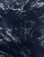
The weather in Maldives is affected by the large landmass of the South Asia to the north. The presence of this landmass causes differential heating of land and water. Scientists also cite other factors in the formation of monsoons, including the barrier of the Himalayas on the northern fringe of the South Asia and the sun's northward tilt, which shifts the jet stream north. These factors set off a rush of moisture-rich air from the Indian Ocean over the South Asia, resulting in the southwest monsoon. The hot air that rises over the South Asia during April and May creates low-pressure areas into which the cooler, moisture-bearing winds from the Indian Ocean flow. In Maldives, the wet southwest monsoon lasts from the end of April to the end of October and brings the worst weather with strong winds and storms. In May 1991 violent monsoon winds created tidal waves that damaged thousands of houses and piers, flooded arable land with seawater, and uprooted thousands of fruit trees. The damage caused was estimated at US$30 million.

The shift from the moist southwest monsoon to the dry northeast monsoon over the South Asia occurs during October and November. During this period, the northeast winds contribute to the formation of the northeast monsoon, which reaches Maldives in the beginning of December and lasts until the end of March. However, the weather patterns of Maldives do not always conform to the monsoon patterns of the South Asia. Rain showers over the whole country have been known to persist for up to one week during the midst of the dry season.

Labels: , , , , , , , , , ,

<$


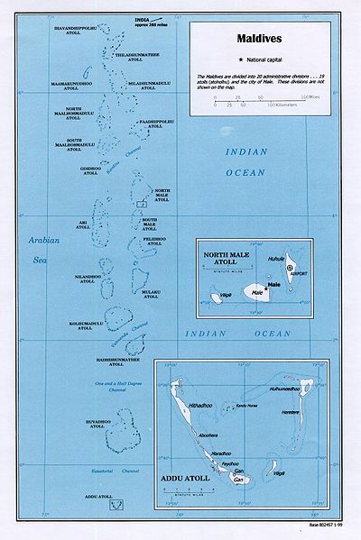
Maldives is a country of South Asia, situated in the Indian Ocean, south-southwest of India. It consists of approximately 1,196 coral islands grouped in a double chain of 27 atolls, spread over roughly 90,000 square kilometers, making this one of the most disparate countries in the world. Composed of live coral reefs and sand bars, the atolls are situated atop a submarine ridge 960 kilometers long that rises abruptly from the depths of the Indian Ocean and runs from north to south. Only near the southern end of this natural coral barricade do two open passages permit safe ship navigation from one side of the Indian Ocean to the other through the territorial waters of Maldives. For administrative purposes the Maldives government organized these atolls into nineteen administrative divisions.

The largest island of Maldives is Fuvammulah, which is a single island and single atoll located in the southern part of the Maldives known as Gnaviyani Atoll in the administrative division. In Addu Atoll the westernmost islands are connected by roads over the reef and the total length of the road is 12 km.

Geographic coordinates: 3°15′N 73°00′E


Physiography

Most atolls consist of a large, ring-shaped coral reef supporting numerous small islands. Islands average only one to two square kilometers in area, and lie between one and 1.5 meters above mean sea level. The highest island is situated at three meters above sea level. Maldives has no hills or rivers. Although some larger atolls are approximately 50 kilometers long from north to south, and 30 kilometers wide from east to west, no individual island is longer than eight kilometers.

Each atoll has approximately five to ten inhabited islands; the uninhabited islands of each atoll number approximately 20 to 60. Several atolls, however, consist of one large, isolated island surrounded by a steep coral beach. The most notable example of this type of atoll is the large island of Fuvammulah situated in the middle of the Equatorial Channel.

The tropical vegetation of Maldives comprises groves of breadfruit trees and coconut palms towering above dense scrub, shrubs, and flowers. The soil is sandy and highly alkaline, and a deficiency in nitrogen, potash, and iron severely limits agricultural potential. Ten percent of the land, or about 26 km², is cultivated with taro, bananas, coconuts, and other fruit. Only the lush island of Fuvammulah produces fruits such as oranges and pineapples partly because the terrain of Fuvammulah is higher than most other islands, leaving the groundwater less subject to seawater penetration. Freshwater floats in a layer, or "lens," above the seawater that permeates the limestone and coral sands of the islands. These lenses are shrinking rapidly on Male and on many islands where there are resorts catering to foreign tourists. Mango trees already have been reported dying on Male because of salt penetration. Most residents of the atolls depend on groundwater or rainwater for drinking purposes. Concerns over global warming and a possible long-term rise in sea level as a result of the melting of polar ice are important issues to the fragile balance between the people and the environment of Maldives in the 1990s.

Labels:

<$

Maldives has twenty-six natural atolls which have been divided into twenty administrative atolls and one city. [2] The northern most atoll is Haa Alif Atoll and the southern most is Seenu Atoll. The smallest atoll is Gnaviyani Atoll with only one island (the largest island in Maldives). The largest atoll in both Maldives and the whole world is Gaafu Alif Atoll which is just south of the One and a Half Degree Channel.

Each atoll is administered by an Atoll Chief (Atholhu Veriyaa) appointed by the President (Maumoon Abdul Gayoom). Atoll chiefs administer as directed by the president. The Ministry of Atoll Administration and its Northern and Southern Regional Offices, Atoll Offices and Island Offices are collectively responsible to the President for Atolls Administration. The administrative head of each island is the Island Chief (Katheeb), appointed by the President. The Island Chief's immediate superior is the Atoll Chief.

Labels: , , , , , , ,

<$
Ustaz Mohamed Rasheed Ibrahim from Fuvahmulah is the present chief justice of Maldives. All judges in the Maldives are appointed by the president. Islamic law is the basis of all judicial decisions.

The Maldives have, in cooperation with the United Nations Development Project (UNDP), undertaken to write the first Muslim criminal code in the history of the world. This project would formalize the proceedings of criminal justice in this tiny nation to one of the most comprehensive modern criminal codes in the world. The code has been written and awaits action by the parliament.


[edit] Maldives and the Indian Ocean Commission
Since 1996, Maldives has been the official progress monitor of the Indian Ocean Commission. Since 2002, the Maldives has expressed interest in the work of the Indian Ocean Commission but has not applied for membership. The interest of the Maldives relates to its identity as a small island state, especially in relation to matters of economic development and environmental preservation, and its desire to forge close relations with France, a main actor in the IOC region. The Maldives is a founder member of the South Asian Association for Regional Co-operation, SAARC, and as former protectorate of Great Britain, joined the Commonwealth in 1982, some 17 years after gaining independence from Great Britain. The Maldives enjoys close ties with Seychelles and Mauritius, whom like the Maldives are members of the Commonwealth. The Maldives and Comoros are also both members of the Organisation of Islamic Conference. The Maldives has refused to enter into any negotiations with Mauritius over the demarcation of the maritime border between the Maldives and the British Indian Ocean Territory, pointing out that under international law, the sovereignty of the Chagos archipelago rests with the UK, with whom negotiations were started in 1991.

Labels: , , , , , , , , ,

<$
Politics in the Maldives takes place in the framework of a presidential republic, whereby the President is the head of government. The President heads the executive branch and appoints the cabinet. The President is nominated to a five-year term by a secret ballot of the Majlis (parliament), a nomination which must be confirmed by national referendum.

The unicameral Majlis of the Maldives is composed of fifty members serving five-year terms. Two male members from each atoll are elected directly by universal suffrage. Eight are appointed by the president, which is the main route through which women enter parliament. The country introduced political parties for the first time in its history in July 2005, six months after the last elections for the parliament. Nearly 36 members of the existing parliament joined the Dhivehi Raiyyathunge Party (which translates to Maldivian People's Party) and elected President Gayoom as its leader. Twelve members of parliament became the Opposition and joined the Maldivian Democratic Party. Two members remained independent. In March 2006, President Gayoom published a detailed Roadmap for the Reform Agenda, providing time-bound measures to write a new Constitution, and modernise the legal framework. Under the Roadmap, the government has submitted to the Parliament a raft of reform measures. The most significant piece of legislation passed so far is the Amendment to the Human Rights Commission Act, making the new body fully compliant with the Paris Principles.

The 50 members of parliament sit with an equal number of similarly constituted persons and the Cabinet to form the Constitutional Assembly, which has been convened at the initiative of the President to write a modern liberal democratic constitution for the Maldives. The Assembly has been sitting since July 2004, and has been widely criticised for making very slow progress. The Government and the Opposition have been blaming each other for the delays, but independent observers attribute the slow progress to weak parliamentary traditions, poor whipping (none of the MPs were elected on a party ticket) and endless points of order interventions. Progress has also been slow due to the commitment of the main opposition party, MDP to depose President Gayoom by direct action ahead of the implementation of the reform agenda, leading to civil unrest in July-August 2004, August 2005 and an abortive putsch in November 2006. Significantly, the leader of the MDP, Ibrahim Ismail, MP for the biggest constituency, Male', resigned from his party post in April 2005 and eventually left MDP in November 2006 citing the intransigence of his own National Executive Committee. The government had engaged the services of a Commonwealth Special Envoy Tun Musa Hitham to facilitate all party dialogue, and when the MDP boycotted him, enlisted the services of the British High Commissioner to facilitate a dialogue. The ensuing Westminster House process made some progress but was abandoned as MDP called for the November revolution.

The call for an Orange Revolution on 10 November by MDP is seen as a mistake by many observers and even supporters, leading to fragmentation of the party and alienation of the members of the public. According to the registrar of parties, the DRP is the largest party in the country with over 35,000 card carrying members while the MDP, the second largest party, has 14,000.

The Roadmap provides the deadline of 31 May 2007 for the Assembly to conclude its work and to pave the way for the first multiparty elections in the country by October 2008.

On 19 June 2006, the Assembly voted to hold a public referendum to decide the form of government under the new constitutional settlement.

Labels: , , , , , , , , ,


Image Hosted by ImageShack.us


WEATHERForecast: 15-Day Overview
Google

Archives

Powered By

Powered by Blogger


I NEED A VOCATION Maldives Welcome to Maldives A little bit of Maldives maldives sky map Maldives Part One Maldives Part Two VOCATION IN PARADİSE
Live Flight Information


google adwords reklam Super Bowl 2010 Live